ZJU scientists obtain free USArray data by seismic imaging
The research team led by CHEN Yangkang of the Zhejiang University School of Earth Sciences conducted research based on USArray data and put forward a novel approach to reconstructing missing traces and suppressing noise simultaneously. Relevant findings are published online in the Sept. 30 issue of the journal of Nature Communications.
USAarray, a key seismology component of the national earth science program EarthScope, is extensively distributed across the North American continent and provides open-source seismic data for scientists. Despite determined and constant efforts to ameliorate the acquisition design, network irregularity still causes spatial sampling alias and incomplete, noisy data, which poses major challenges to array-based data analysis and seismic imaging.
In this study, researchers develop an effective framework to reconstruct the three-dimensional (3D) data of an earthquake recorded by USArray. They propose a localized rank-reduction method to simultaneously reconstruct the missing traces and improve the weak-amplitude phase arrivals. Compared with the regular global rank-reduction method, their localized approach is superior at preserving small-scale features in array data, which is critical for high-resolution imaging of subsurface structures.
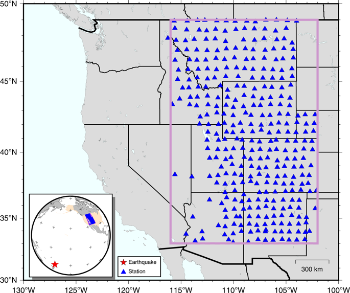
The distribution of USArray stations in this study. The lateral dimension of the reconstructed data volume is highlighted by the rectangle. A large portion of the data is missing due to relatively spare station coverage in the southwest. The inset shows the location of the earthquake (red star) relative to the recording array (blue triangles).
They exploit a synthetic dataset and apply the proposed method to January 18, 2009, Kermadec Islands Mw 6.4 earthquake recorded by USArray, where a significant portion of the recordings is missing due to deployment limitations. The reconstructed earthquake wavefield provides the virtual recordings at the missing locations as if they had been acquired by the actual stations during the earthquake. In their study, they also make cross-correlation measurements of P-wave arrival times, a fundamental step in body-wave travel time tomography. This reconstructed P wavefield enhances the spatial coherency and accuracy of tomographic travel time measurements, indicative of great potential to benefit seismic investigations based on array techniques.
The development of imaging technology, such as the one proposed in this study, should work hand in hand with the improvement in data acquisition to achieve the ultimate goal of having a better understanding of the Earth’s structure.